Sign up for FlowVella
Sign up with FacebookAlready have an account? Sign in now
By registering you are agreeing to our
Terms of Service
Loading Flow

Downloading Image /
Downloading Image /
Downloading Image /
Downloading Image /
Downloading Image /
Downloading Image /
Downloading Image /


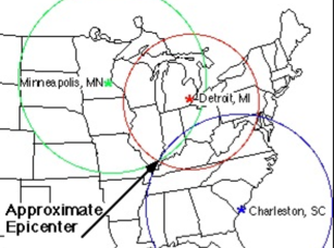
1. Check the scale on your map. It should look something like a piece of a ruler. All maps are different. On your map, one centimeter could be equal to 100 kilometers or something like that.
2.Figure out how long the distance to the epicenter (in centimeters) is on your map. For example, say your map has a scale where one centimeter is equal to 100 kilometers. If the epicenter of the earthquake is 215 kilometers away, that equals 2.15 centimeters on the map.
3.Using your compass, draw a circle with a radius equal to the number you came up with in Step #2 (the radius is the distance from the center of a circle to its edge). The center of the circle will be the location of your seismograph. The epicenter of the earthquake is somewhere on the edge of that circle.
Finding Location of a Earthquake
Part 2
Downloading Image /
Downloading Image /
Downloading Image /
Downloading Image /
Downloading Image /
Downloading Image /
Downloading Image /
Downloading Image /
Downloading Image /
Downloading Image /
Downloading Image /
Downloading Image /

FlowVella, Previously Known As Flowboard
© 2025 FlowVella
