Sign up for FlowVella
Sign up with FacebookAlready have an account? Sign in now
By registering you are agreeing to our
Terms of Service
Loading Flow


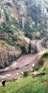
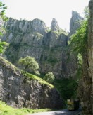
The Gorge is cut into the Carboniferous Limestone, which here dips at about 20° to the south-west. As you travel down the gorge the dip causes successively younger rocks to descend to road level. The pale grey Burrington Oolite. outcrops around Black Rock Gate, while most of the gorge is cut into the Clifton Down Limestone. At the base of the gorge the Oxwich Head Limestone occurs at road level. The cliffs on the south side are dominantly vertical, cut along major fractures whereas the northern slopes are formed along the dipping bedding planes.
THE GEOLOGY OF CHEDDAR...


Cheddar Gorge refers to a limestone gorge in the Mendip Hills, which was formed over three hundred million years ago, in a sea with a sandstone floor. Sea organisms and several plants rained down on the sea base, calcium within them forming huge thicknesses of limestone. Earth movements finally pushed this sea base above sea level as a plateau.