Sign up for FlowVella
Sign up with FacebookAlready have an account? Sign in now
By registering you are agreeing to our
Terms of Service
Loading Flow

Downloading Image /
Downloading Image /
Downloading Image /
Downloading Image /
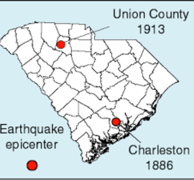
The earthquake took place before seismological instrumentation, estimates of its location and size must come from observations of the damage and effects caused by the earthquake. Most of what we know of the even and the resulting damage comes from a comprehensive report by C.E. Dutton of the U.S. Geological Survey published in 1889. The area of maximum damage (meizoseismal area) of the 1886 earthquake is an elliptical area roughly 20 by 30 miles trending northeast between Charleston and Jedburg and including Summerville and roughly centered at Middleton Place.
OF
The earthquake
4


Charleston
Downloading Image /
Downloading Image /
Downloading Image /

FlowVella, Previously Known As Flowboard
© 2026 FlowVella
