Sign up for FlowVella
Sign up with FacebookAlready have an account? Sign in now
By registering you are agreeing to our
Terms of Service
Loading Flow


The Huai River
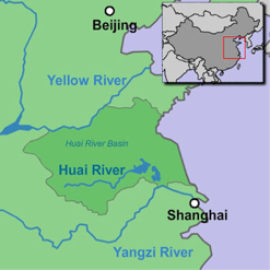
The Huai River or HuaiHe (淮河) was under the control of the Zhou and Shang dynasty. It is located in between the Yellow River and Yangtze River, and is geographically known as the 'dividing line between North and South China'. It is 1078 km long and has an area of 187 000 square kilometres.The Huai River flows from west to east, and passes through the states of Henan, Anhui, and Jiangsu. Its source is from Tongbai Mountain and flows into the Yangtze River.
The Huai River is known for its flooding and the second stage of flood control began in 1957. In 2007, it had the biggest flood that had ever occurred for the last 50 years. Since Ancient times, the Huai River has gotten larger and there has also been construction work on it as well. They have repaired and improved the grand canal, which is a main route of river transport that lead out to the Yellow and Yangtze River.
淮河 HuaiHe

BY TIFFANY HONG

