Sign up for FlowVella
Sign up with FacebookAlready have an account? Sign in now
By registering you are agreeing to our
Terms of Service
Loading Flow

Downloading Image /
Downloading Image /
Downloading Image /
Downloading Image /
Downloading Image /
Downloading Image /
Downloading Image /
Downloading Image /
Downloading Image /
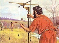
-This tools was known as the Decempa, and it was used to measure and plot roads
-Roman surveyors were masters at using these tools to plan the building of roads
-The tools helped to align the roads with the four cardinal directions, and keep them straight
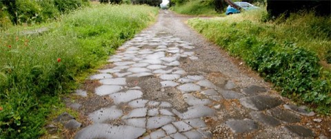
-For 7 centuries, Roman road building continued, until economic decline and external pressure began to give way
-By the fall of the West in 476 AD, the condition of the roads paralleled the circumstances of the empire, and many roads fell into disuse, disrepair, and ruin throughout the medieval age
Downloading Image /
Downloading Image /
Downloading Image /
Downloading Image /
Downloading Image /
Downloading Image /
Downloading Image /
Downloading Image /
Downloading Image /
Downloading Image /
Downloading Image /
Downloading Image /
Downloading Image /
Downloading Image /
Downloading Image /

FlowVella, Previously Known As Flowboard
© 2026 FlowVella
