Sign up for FlowVella
Sign up with FacebookAlready have an account? Sign in now
By registering you are agreeing to our
Terms of Service
Loading Flow

Downloading Image /


Causes
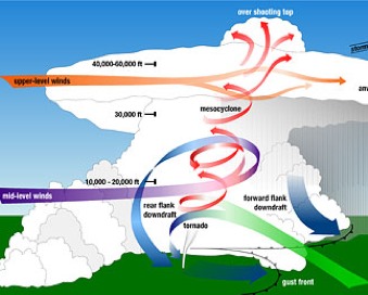


They are caused when different temperatures and humidity meet to form thunderclouds. In the United States, warm, wet winds from the Gulf of Mexico move northward in spring and summer, meeting colder, dry Canadian winds moving southward. The place where these two winds meet is called a dry line. High, dry air coming from the north piles on top of low-moving, moist Gulf air at a height of over 10,000 feet. The warm southern winds try to rise, but the cold northern air blocks them. This clash causes the warm, trapped air to rotate horizontally between the two air masses. At the same time, the sun heats the earth below, warming more air that continues to try and rise. Finally, the rising warm wind become strong enough to force itself up through the colder air layer. When this occurs, the cold air on top begins to sink, sending the rising warm wind spinning upward. The warm winds rotate faster and faster in a high column. When the updraft is strong, the column can rise to heights of 10 miles or more, twisting at speeds of up to 100 miles an hour. The rotating winds produce strong storm clouds about 70,000 feet high, sometimes spreading 10 miles wide.
Downloading Image /
Downloading Image /
Downloading Image /
Downloading Image /
Downloading Image /
Downloading Image /
Downloading Image /
Downloading Image /
Downloading Image /
Downloading Image /
Downloading Image /

FlowVella, Previously Known As Flowboard
© 2025 FlowVella
