Sign up for FlowVella
Sign up with FacebookAlready have an account? Sign in now
By registering you are agreeing to our
Terms of Service
Loading Flow

Downloading Image /
Downloading Image /
Downloading Image /
Downloading Image /
Downloading Image /
Downloading Image /
Downloading Image /
Downloading Image /
Downloading Image /
Downloading Image /
Downloading Image /
Downloading Image /
Downloading Image /
Downloading Image /
Downloading Image /
Downloading Image /
Downloading Image /
Downloading Image /
Downloading Image /
Downloading Image /
Downloading Image /
Downloading Image /
Downloading Image /
Downloading Image /
Downloading Image /
Downloading Image /
Downloading Image /
Downloading Image /
Downloading Image /
Downloading Image /
Downloading Image /
Downloading Image /
Downloading Image /
Downloading Image /
Downloading Image /
Downloading Image /
Downloading Image /
Downloading Image /
Downloading Image /
Downloading Image /
Downloading Image /
Downloading Image /
Downloading Image /
Downloading Image /
Although the Germans had started building defensive structures along the coast and they anticipated some kind of invasion from Britain, it was considered improbable that any landing would take place at Vierville. The Allies knew that all major ports in France along the English Channel were heavily guarded and that any invasion from the sea entailed a considerable support network. There was no existing harbour which offered a reasonable chance of success. So they decided to do the unthinkable, bring a port with them! In fact the plan was to construct two artificial ports in the British Isles, tow them across the channel and place them off less well defended beaches to supply arms, vehicles, provisions and fuel to their invading troops from the sea.
As you know there is a good reason why there are few proper ports along the Norman coast. The beach at Vierville (and Courseulles, Arromanches etc. ) experiences a huge difference between high and low tides. An invasion force cannot afford to be marooned on the sand while waiting for the tide to come in. So any port you construct must be able to move up and down to be useful 24/24. They invented special hydraulic legs for platforms which rise and descend with the water level, they designed piers and roads made of floating pontoons.
There were to be two main ports Mulberry 1 (Vierville, St.Laurent) and Mulberry 2 (Arromanches) to support troops that would land at five main staging areas. Utah Beach where the Americans would focus on the Cherbourg penninsula, Omaha Beach at Vierville where the Americans were to penetrate to St. Lo, Gold at Arromanches where the British were to reach Bayeux, Juno at Courseulles where Canadians were to coordinate with British who would have landed at Sword at Lion sur Mer and head for Caen. A fuel pipeline would come in at St Honorine near Colleville.
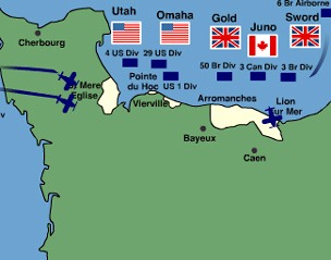
ALLIED PLANS
Downloading Image /
Downloading Image /
Downloading Image /
Downloading Image /
Downloading Image /
Downloading Image /
Downloading Image /
Downloading Image /
Downloading Image /
Downloading Image /
Downloading Image /
Downloading Image /
Downloading Image /
Downloading Image /
Downloading Image /
Downloading Image /
Downloading Image /
Downloading Image /
Downloading Image /
Downloading Image /
Downloading Image /
Downloading Image /
Downloading Image /
Downloading Image /
Downloading Image /
Downloading Image /
Downloading Image /
Downloading Image /
Downloading Image /
Downloading Image /
Downloading Image /
Downloading Image /
Downloading Image /
Downloading Image /
Downloading Image /
Downloading Image /
Downloading Image /
Downloading Image /
Downloading Image /

FlowVella, Previously Known As Flowboard
© 2026 FlowVella
