Sign up for FlowVella
Sign up with FacebookAlready have an account? Sign in now
By registering you are agreeing to our
Terms of Service
Loading Flow

Downloading Image /
Downloading Image /
Downloading Image /
Downloading Image /
Downloading Image /
Downloading Image /
Downloading Image /
Until the middle of the nineteenth century, land either belonged to nobility or it was common.
So for example, the chateau, the Vaumicelle, the Ferme d'Ormel and associated lands was private property, and many villagers lived in houses on that land, but they did not own the buildings or the land.
The only record of building along the sea front before the end of the 1800s is mention of a shepherd's shelter along the marshy strip at the bottom of the cliffs.
Presumably there were buildings associated with the port, but I have not found any records. There is reference to a market at the beach and it makes sense that there would be some fishing shacks at the time of the "cabestans" winches, but I have found no evidence.
By 1823 common land was drawn in 4 sections, roughly indicated as north or south and categorized as "vignets" (likely based on vignots, arid, pebbly land where Romans introduced wine) or "falaises" (which included the land reaching to the sea).
This common land was first divided in 1830.
However, it was only in 1846 that lots (literally, the villagers drew lots...straws) were drawn and the land was divided up among the 85 families.
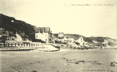
In 1870 the first chalets were built along the seashore.
The road along the coast was only built in 1900-01 on land given up by the lot holders and named after a mayor, Etienne de Cauvigny (mayor 1895-1907, 1908-1912). At that time, lines of wooden staves were dug into the beach to protect the road.
FIRST PROPERTY DIVISIONS
X
/
Downloading Image /
Downloading Image /
Downloading Image /
Downloading Image /
Downloading Image /
Downloading Image /
Downloading Image /
Downloading Image /
Downloading Image /
Downloading Image /
Downloading Image /
Downloading Image /
Downloading Image /
Downloading Image /
Downloading Image /
Downloading Image /
Downloading Image /
Downloading Image /
Downloading Image /
Downloading Image /
Downloading Image /
Downloading Image /
Downloading Image /
Downloading Image /
Downloading Image /
Downloading Image /
Downloading Image /
Downloading Image /
Downloading Image /
Downloading Image /
Downloading Image /
Downloading Image /
Downloading Image /
Downloading Image /
Downloading Image /
Downloading Image /
Downloading Image /
Downloading Image /
Downloading Image /
Downloading Image /
Downloading Image /
Downloading Image /
Downloading Image /
Downloading Image /
Downloading Image /
Downloading Image /
Downloading Image /
Downloading Image /
Downloading Image /
Downloading Image /
Downloading Image /
Downloading Image /
Downloading Image /
Downloading Image /
Downloading Image /
Downloading Image /
Downloading Image /
Downloading Image /
Downloading Image /
Downloading Image /
Downloading Image /
Downloading Image /
Downloading Image /
Downloading Image /
Downloading Image /
Downloading Image /
Downloading Image /
Downloading Image /
Downloading Image /
Downloading Image /
Downloading Image /
Downloading Image /
Downloading Image /
Downloading Image /
Downloading Image /
Downloading Image /

FlowVella, Previously Known As Flowboard
© 2026 FlowVella
